

The Man Who Drew Hermosa
Exactly 125 years ago today, a kid from Ohio with nothing to do helped survey a town in the sand dunes. Hermosa Beach's 'First Citizen' never left.
Southern California's beaches grew by over 2 million square meters in 40 years — contradicting chronic erosion warnings. The problem isn't sand shortage, says a new federal study, but that coastal structures block sediment from reaching beaches that need it most.

A landmark study published last month in Nature Communications is turning heads among coastal scientists — and is relevant to anyone who lives along the South Bay waterfront.
The study, led by researchers from the U.S. Geological Survey and UC Irvine, analyzed 40 years of satellite imagery to track beach changes along the entire California coast. Their headline finding: Southern California's beaches, as a region, are growing, not shrinking — accumulating more than 2 million square meters of new beach area between 1984 and 2024.
Using a newly developed technique to extract precise shoreline measurements from Landsat and Sentinel-2 satellite imagery, the researchers tracked changes across 320 kilometers of Southern California coastline — the most comprehensive and accurate assessment ever conducted of the region's beaches.
"There's been a number of reports suggesting that Southern California beaches are disappearing," said Brett Sanders, Chancellor's Professor of Engineering, Urban Planning and Public Policy at UC Irvine and one of the study's lead authors. "What surprised the research team was that the most urbanized and heavily dammed segment of the California coastline — from Santa Barbara down to San Diego — beaches there were growing at a time when you might think that because of all the human influence, they might be shrinking."

Their finding directly contradicts prior studies that had declared Southern California in a state of "chronic erosion." Those earlier assessments, the authors note, were based on only two or three historical shoreline measurements with large uncertainties. The new satellite-derived dataset provides annual measurements over four decades, reducing measurement error by nearly an order of magnitude.
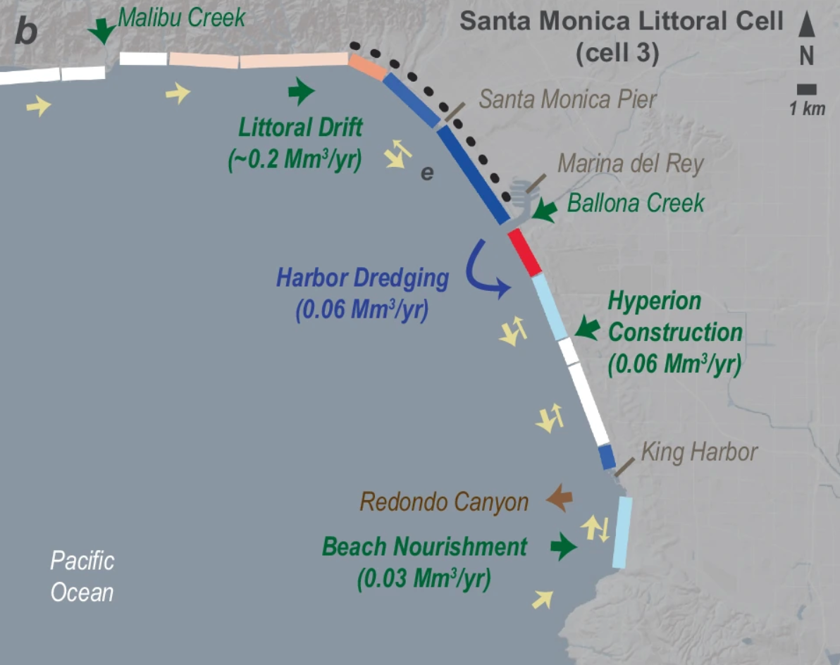
Hermosa Beach sits within what scientists call the Santa Monica littoral cell — a continuous band of sand transport stretching from Malibu to the Palos Verdes Peninsula. The study found this littoral cell has experienced a statistically significant widening trend of roughly 11,600 square meters of new beach area per year over the study period.
The Santa Monica cell's growth is driven primarily by longshore sediment transport — sand moving southward along the coast from Malibu Creek and the Santa Monica Mountains — and by the way coastal structures interrupt that flow. Marina del Rey, just north of Venice Beach, acts as a sand trap, concentrating sediment along the central portion of the cell. Venice Beach, which lies just up the coast from Hermosa, has been widening at a rate of 1.5 meters per year and now stretches roughly 200 meters from the waterline to the boardwalk.
The Hermosa Review spoke this week with Professor Sanders about what the study's findings mean specifically for our beach.
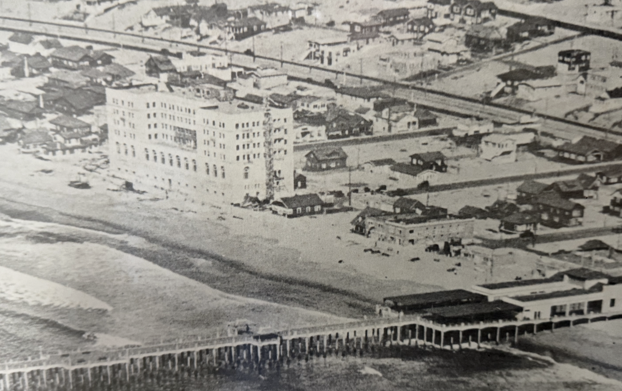
Sanders confirmed that the stretch of beach from the Hermosa pier south to King Harbor is colored blue in the study's Figure 4B — the color indicating measurable, statistically significant widening. His estimate for our beach: approximately one meter of widening per year over the 1984-2024 measurement period.
The primary mechanism, Sanders explained, is the way King Harbor's jetty interrupts the natural southward flow of sand along the coast. Waves arriving from the west in winter push sediment southward along the coast; summer's southerly waves push some back, but the net movement is toward King Harbor. When that moving sand reaches the jetty structure, it has nowhere to go — and accumulates on the updrift side. "Your beach is sort of, in some sense, benefiting from this blockage of sediment from the structure," Sanders said.
He also identified two major historical contributors to Hermosa's sand supply: the construction of Marina del Rey, whose jetties trap enormous volumes of northerly sediment, and the construction of the Hyperion Treatment Plant, whose excavation of coastal bluffs deposited large quantities of material onto nearby beaches, which then moved down the coast. "I would say that probably a bigger influence on your long-term record would have been the Hyperion construction," Sanders said. "I think those two projects delivered large volumes of sand into the region."
Local historians have also pointed to the demolition of the old Biltmore Hotel, whose debris was deposited offshore and may perhaps function as a subsurface breakwater. Sanders was intrigued by the account but suggested Hyperion was likely the more significant factor.
Despite the good news for Hermosa, Sanders was careful to frame the regional picture accurately. The problem in Southern California isn't a sand shortage — it's a distribution problem.
"There are beaches that are really significantly impacted by narrowing, but there's also beaches that are widening," he said. "The point is that the beaches that are widening offset the beaches that are narrowing on average." About 30 percent of the Southern California shoreline experienced significant narrowing during the study period, even as the regional total grew. Sand accumulates where structures concentrate it; beaches downdrift of those same structures can starve.
The study's broader value, Sanders argued, is in giving coastal managers the data to make smarter decisions. "When sediment is placed in particular areas, it will spend a long period of time moving down the coast and benefiting many communities," he said. "This type of data is really going to help coastal managers come up with better interventions — smarter interventions that are good for California's economy and good for California's precious resource of the beach."
The authors point to harbor sediment bypass systems, routine maintenance dredging, and planned dam removal projects as tools that could spread sediment more equitably along the coast. They also acknowledge the barriers: cost, regulation, politics, and institutional resistance to change.
During the interview, we mentioned to Professor Sanders that Hermosa Beach may have historically sold sand to Hawaii — that some of the sand on Waikiki and Kauai came from our beach. He was visibly surprised. "Oh, wow," he said, before engaging enthusiastically with the broader point about the global sand economy and the growing scarcity of construction-grade sand worldwide.
The Hermosa Review is continuing to research the documentary record of those sand sales. The well-established historical account of California-to-Hawaii sand shipments in the 1920s and 1930s centers on Manhattan Beach, where the Kuhn Brothers Construction Company loaded excess dune sand onto railroad cars bound for San Pedro Harbor and then by barge to Waikiki. Whether Hermosa Beach sand made the same journey — at that time or since — is a question we are still working to confirm. If you have documents, photographs or family accounts bearing on this history, we'd welcome hearing from you.

A Los Angeles Superior Court judge tentatively sided with a local homeowner on Wednesday, finding the city acted outside its authority when it banned short-term rentals without state approval.


Second undercover sting operation at Cypress Avenue venue by ABC officers results in citation and provisional court date.

License plate scheme proposed in new State Assembly legislation
By Hermosa, for Hermosa. Join The Review today.